Using GISBox to optimize 3D data conversion from OSGB to 3DTiles
In the field of geographic information systems (GIS) and 3D visualization, OSGB (OpenSceneGraph Binary) and 3DTiles are two widely used 3D data formats. The OSGB format is often used to store complex 3D terrain and building models, while 3DTiles is a 3D tile format optimized for network transmission and rendering. This article will introduce in detail how to convert OSGB format data to 3DTiles format in GISBox to meet the needs of online browsing and efficient rendering.
The OSGB format occupies an important position in 3D modeling with its rich 3D information (including point clouds, textures, surface normal vectors, etc.). However, as 3D data continues to grow, how to efficiently manage and transmit this data has become a challenge. The 3DTiles format emerged as the times require. It supports a variety of data compression algorithms and streaming rendering technologies, which can significantly improve data transmission and display efficiency. Therefore, converting OSGB models to 3DTiles models can facilitate users to browse and use these three-dimensional data online.
Operation process of converting OSGB to 3DTiles in GISBox
GISBox is a professional 3D data processing tool that supports the conversion and processing of multiple 3D data formats. Here are the detailed steps to convert OSGB to 3DTiles using GISBox:
1. Create a new tiling task
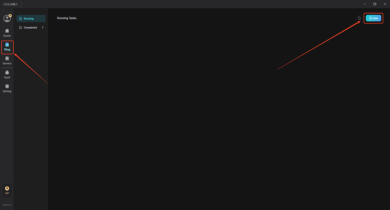
Open the GISBox software, in the “Tiling”, click the “New ” button on the upper right to create a tilng task.

2. Add OSGB file
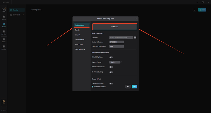
In the pop-up “New Tiling Task” window, we select the type of tile — tilted model tile, and then click the “+ Add File” button above to add our local OSGB file.

3. Set conversion parameters and start tiling
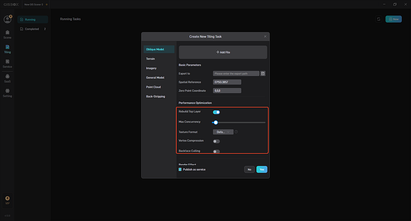
After adding the OSGB file, you can set the folder path for tile export in “Basic Parameters”. “Spatial Reference” and “Zero Point Coordinates” will be automatically generated based on the “metadata.xml” file in the folder. When the amount of tilted 3D model data is large, you can choose to turn on the “Rebuild Top Layer” function, which can significantly improve loading performance and enhance the browsing experience.

In “Storage Type”, “Store 3DTiles1.1” is enabled by default. When turned on, the model files in the OSGB folder are exported to glb format. When closed, it is in b3dm format.
4. Service distribution and viewing
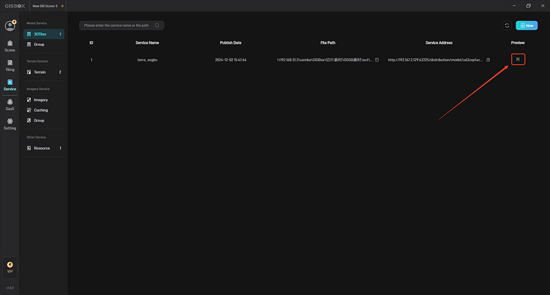
If “Publish as service” is checked in the tiling task settings, the corresponding service will be automatically generated when the tiling is completed. Click the “Service” on the left, and then select the first model service to see the generated service. For services, you can click to copy the service address, or click the “View” button to preview it in the browser.

Through GISBox software, we can easily convert 3D models in OSGB format to 3DTiles format to achieve efficient management and transmission of 3D data. This conversion process not only improves the efficiency of data processing, but also enhances the user experience. Therefore, GISBox is one of the ideal tools for OSGB to 3DTiles conversion. Whether you are a professional GIS practitioner or a 3D data enthusiast, you can use GISBox to explore more possibilities for 3D data conversion and visualization.