GISBox-Three free features help cities upgrade digitally


In the field of urban planning, geographic information systems (GIS) play a vital role. However, traditional GIS software is often expensive and complicated to operate, which makes many practitioners discouraged. However, GISBox, which I will introduce to you today, has brought new vitality and convenience to urban planning with its powerful free functions.
1. Free data publishing function
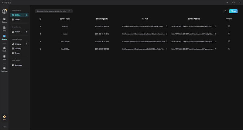
In the process of urban planning, data publishing and sharing are extremely critical links. GISBox’s free data publishing function makes this process easy and simple. It supports mainstream publishing protocols such as 3D tiles, terrain, and WMTS, and is completely free. For example, when you need to integrate urban terrain data, building data, and satellite image data, and provide them to different departments for collaborative use, with the help of GISBox, you can quickly publish the processed data as a service, and team members and partners can access it at any time. This greatly improves work efficiency and makes project progress smoother. By sharing data in real time, different departments can work based on the same data source, avoiding communication costs and errors caused by inconsistent data.
2. Real-time editing of oblique photography
The accuracy of urban terrain data directly affects the scientificity and rationality of planning. GISBox’s real-time editing function for oblique photography can conveniently process and optimize oblique photography data. In actual operation, functions such as fracture repair, riverbed settlement processing, and terrain alignment are very practical. For example, when processing urban oblique photography data, the data may have damaged parts, which will hinder subsequent visualization analysis. However, using the fracture repair function of GISBox, these damaged parts can be quickly repaired to make the data more complete and accurate, providing a reliable data foundation for urban planning. Through real-time editing, planners can adjust the data in time according to the on-site conditions to ensure that the planning scheme is highly consistent with the actual terrain.

3. Multi-format conversion support
In urban planning, various GIS data formats are involved. GISBox supports conversion of multiple formats such as GeoTiff, OSGB, PVT, FBX, OBJ, etc., which greatly improves the flexibility of data processing. In a new urban area planning project, it was necessary to convert the GeoTiff format data of satellite images into 3DTiles format for use in a 3D visualization platform. After conversion using GISBox, the data quality is high and perfectly meets the project requirements. This powerful format conversion capability enables data from different sources and formats to be effectively integrated and utilized in urban planning work, breaking the barriers of data formats.

4. User-friendly interface
For novices who are new to urban planning and GIS technology, operating complex software is a big challenge. The user interface of GISBox is designed to be very easy to understand, and even beginners with no experience can quickly get started. It is not only simple to operate, but also has rich functional options, from basic data viewing and editing to advanced analysis and modeling, meeting the different needs of novices to professionals. Many new urban planners who have just joined the company have mastered the basic operations in a short time after using GISBox, and can smoothly use some advanced functions to assist their work, greatly shortening the growth cycle of novices.
5. Summary
GISBox provides efficient, convenient and low-cost solutions for the field of urban planning with its free data publishing, real-time editing of oblique photography, multi-format conversion and user-friendly interface. Both small project teams and large urban planning agencies can benefit from the free functions of GISBox. If you are still worried about data processing, analysis and other issues in urban planning, you might as well try this tool. I believe it will bring you unexpected surprises.